From the publication of the Localism Act (2011) there has been general pressure from central government to make data held by local authorities more readily available. I think most people would generally accept that this is a good thing, even if the lack of context in the data resulted in headaches with its interpretation from time-to-time.
In fact, when I was Leader of the Opposition on Crawley Borough Council, I once had a resident call to tell me that the payment data showed the Tories had clearly hired the London Philharmonic Orchestra to play for their Christmas Party. While I thanked the gentleman for his enthusiasm, I did have to explain to him that a more likely explanation was that it was a payment for their performance at the Hawth which had taken place during that reporting period.
The truth is that while most attention, understandably, is focused on council expenditure you don’t tend to have a ‘gottcha’ moment by going line-by-line through the data, councils are subject to extensive internal and external auditing annually, so anything obvious will be picked up on (councils which go under have more substantial issues). If anything meaningful is to be found it will be in the aggregate–often combining multiple data releases–to find where annual expenditure to a company or for a good or service over the course of a year seems excessive.
Personally, I find the land ownership data more interesting. As a councillor, I have access to the council’s own internal GIS, which contains a vast array of geodata you can overlay on current, historic and technical background maps (while it’s fun to explore, I mostly use it to work out if casework relates to Crawley Borough Council or West Sussex County Council land). However, the volume of data sometimes makes it hard to see the wood for the trees.
For privacy reasons, the data for CBC does not include council housing (although there is a separate spreadsheet which gives some interesting details about the overall stock, including that it has a current market value of £2.4bn), so it’s far less busy.
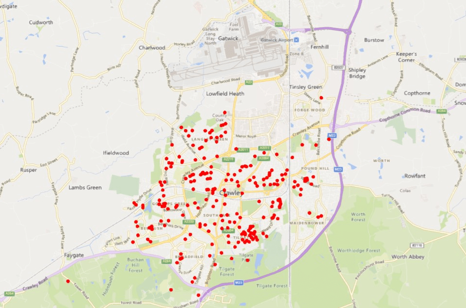
With 838 data points (each highlighting a postcode, rather than showing the full size of the site), going through one by one would quickly get boring, but there are a few things which are interesting to note.
The first is that for both historical and practical reasons we do own one or two sites outside of the borough, with several others having been sold off for various reasons over recent years. We aren’t unique in this, as a number of other councils have both commercial property and housing which they have purchased in the town over the years (in terms of the housing, they are supposed to consult with the council, but very rarely do).
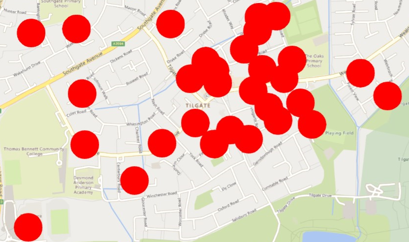
The second is that there is a big cluster in Tilgate of locations. Looking at these records the reason for this goes back to the introduction of Right-to-Buy, where the council at the time wanted to preserve as much land as possible in council ownership, so where properties had large gardens they removed these from the properties and then leased them back to the property owners for a peppercorn rent. This meant that despite the housing being sold, the council retained these sites for housing in the future.
When the council subsequently (just before my time), tried to bring this land forward as housing in a couple of other wards it was incredibly unpopular. In fact, some properties in West Green still have ‘hands off our gardens’ signs up almost two decades on.
While Tilgate isn’t alone in this, something about the layout of Tilgate has resulted in a lot of these gardens under license and–most likely never to be realised–potential for development. So Tilgate will remain very CBC-land heavy.

There is also a dearth of CBC land both in Maidenbower, and the Worth and Crabbet Park sections of Pound Hill. The reason for this is that these areas have largely been brought forward through private development (and even with planning permission from a neighbouring council in the case of Crabbet Park, where the land was based in Mid Sussex at the time).
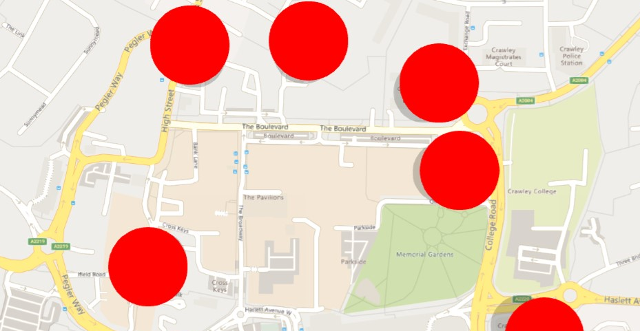
The other location with a general lack of CBC land is the town centre. There’s the Town Hall, Crawley Museum, an access road behind Northgate Road, Kilnmead Car Park and the Ancient Priors, but the council owns none of the retail locations nor any of the public realm, most of which belongs to West Sussex Highways having once been navigable by car.
We have no control over who does or doesn’t go in a shop, what the rents are or what happens to the building, even the business rates are set by central government. Our only ability to change things within the town centre comes from acting as a match-maker between property owners and businesses and trying to persuade landlords to invest in their buildings.
Other than gardens under license, the sites are mostly a combination of neighbourhood parades, community centres, garage blocks, open green spaces, play areas, and leisure facilities. Exactly the kinds of things a district council provides, so no surprises there.
West Sussex is also required to provide all this data. As you might imagine, their buildings in Crawley largely consist of highways land, schools, closed former youth centre and Sure Start Centre buildings, old offices, buildings co-located with CBC (always a nightmare in trying to agree any changes to the properties) and one-offs like libraries and even one of the farms in the safeguarded land by Gatwick.
Unfortunately, each of their property/land data sets is formatted differently and for the most part make it hard to locate exactly where a site is. The worst of this is the ‘vacant building list’ which contains all the property the county owns which currently is being left unused and just provides a postal sector. Fortunately, it’s not hard to work out if you know where WSCC owns property.
In Crawley alone, accounting for just two percent of West Sussex’s area, there are currently 47,330m2 of county council buildings left unoccupied. That’s equivalent to just under seven professional sized football pitches. Meanwhile, a further 40,995m2 of developable land is currently left vacant. One of which is the largest piece of housing land still left in the borough and which has been left overgrown for two-decades now (I pressed this point quite hard when WSCC were trying to shut down all the homeless hostels in 2018, claiming that the boroughs and districts should be doing more to house people).
Across West Sussex as a whole, 2,160,827m2 of county council land and property–and we’re not talking about grass verges here but big sites–is currently completely vacant. Knowing how WSCC operates, I strongly suspect that you could significantly compress the working space the council needs without any impact upon performance, particularly with the move to hybrid working, freeing up even more buildings.
In the end, this brings us back full circle. West Sussex have been facing budget problems for years, both in terms of trying to afford to maintain services despite cuts to their grant from central government and also funding their capital programme of investment in the county’s infrastructure. You won’t find a solution to this going line-by-line through payment card data, but in looking at their assets as a whole, it seems to me that if the county tried to use their vast estate of property and land in the same way as the borough has to generate new revenue streams for the council and to off-set capital expenditure, we might not need to see poor funding driving children’s services in and out of special measures every few years.
Local transparency data
CBC: https://crawley.gov.uk/council-information/access-information/publication-scheme-and-other-data/open-data
WSCC: https://www.westsussex.gov.uk/about-the-council/information-and-data/data-store/local-government-transparency-code-data/
Sussex Police: https://www.sussex.police.uk/police-forces/sussex-police/areas/sd/stats-and-data/
Discover more from Peter Lamb for Crawley
Subscribe to get the latest posts sent to your email.

1 Comment