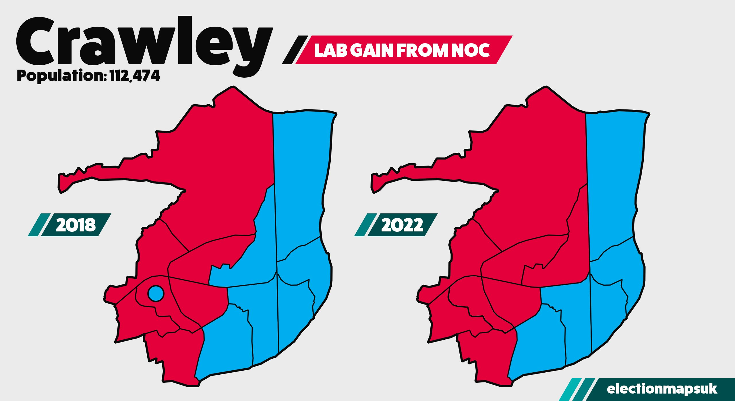
Anyone who has ever looked at a map of Crawley overlaid with any socio-economic data is likely to have noticed that a division appears to exist between the eastern and western parts of the town (something I said I would come back to in an earlier post).
While some datasets produce fuzzier boundaries than others, we see the same split replicated time and time again, most obviously when it comes to voting patterns:
These kinds of divisions in towns aren’t that uncommon, quite the opposite, the division between high income and low income areas along an East-West axis is actually the norm for most large settlements in the UK (whenever Conservatives drone on about ‘for all the ways people go on about ‘North London’ elites, I do find myself reflecting upon how all the money in London happens to actually be in West London where those same Conservatives happen to love).
The reason for this is a simple quirk of history: smoke. For most of human existence our main source of artificial heating has been fire, fires produce smoke and that created appalling air quality in dense urban environments. Smoke doesn’t stand still though, it moves with the wind and consequently the cost of housing tended to follow the direction of the wind.
However, where Crawley is unusual is that while wind typically blows from West to East, the highest cost housing in Crawley tends to be in the East and the lowest cost housing tends to be in the West. The answer as to why this is seems to me to be a combination of the times at which neighbourhoods were being built and who was bringing them forward.
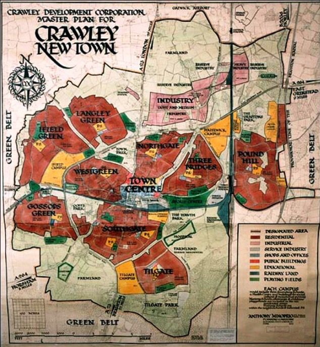
Crawley received its ‘New Town’ designation in 1947. At that time the plan for the town was that it would consist of nine neighbourhoods, beginning with West Green and Northgate. As the map shows, most of what we consider to be East Crawley today wasn’t part of the plan and it is important to note that the section of Pound Hill which was proposed was built the same as the rest of the neighbourhoods, predominantly council housing using the same general pattern.
In 1958, Furnace Green started construction and while I only have oral history to go on, my understanding was that the housing was deliberately intended to provide housing for the town’s middle class professionals and managers, for the first time deviating from the initial pattern of New Town development (there’s also an area of co-operatively built housing in the ward with a fascinating history of its own I don’t have time to go into, but worth having a read-through here).
Presumably much of Pound Hill North, within the boundaries of the map above, followed much the same logic as with Furnace Green in meeting the needs of more middle class residents, but the big change happened with the eastern development of Pound Hill, taking place on land which was based in Mid Sussex until the 1982 Principle Area Review. Mid Sussex had a different philosophy when it came to development, resulting in these areas being built with low levels of council housing and none of the standard ‘Neighbourhood Principle’ infrastructure which you typically associate with a neighbourhood centre in a New Town.
With Margaret Thatcher came the desire to do away with council housing completely, so by the time Maidenbower was under construction, it was essentially built without affordable housing, pricing out local families and resulting in what has at times been the wealthiest division in the entirety of West Sussex.
So, let’s bring this all together. The initial construction of the New Town consisted of neighbourhoods of essentially the same housing types and catering to residents of similar socio-economic status. More middle-class housing was built to cater to local needs as time went on and was built on the land which had not yet been developed, which happened to be located in the East. Further rounds of development were later initiated by neighbouring authorities who lacked the same commitment to council housing and by the time Maidenbower was under construction, council housing was increasingly hard to force into developments. The end result were wealthier populations located in the East, compared to the West.
Of course, residents in these areas were lucky enough not to have to deal with large volumes of smoke in the way that history inflicted upon the denizens of other such towns, as open fires had been largely phased out by the 1970s. We can only wonder what might have happened were this not the case.
Discover more from Peter Lamb for Crawley
Subscribe to get the latest posts sent to your email.

1 Comment